On-top of a hill, north of Newry, Co Down, Fintan Walsh identified interesting evidence for the re-use of early medieval rath DOW046:026.
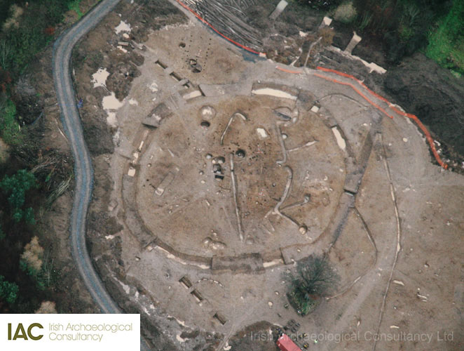
A complex of multi-period archaeological features were identified at Carnmeen and Lisduff, Co. Down during advance archaeological investigation of the proposed extension to Carnbane Industrial Estate, Newry. These sites were subsequently excavated by the author with a crew of 60 field archaeologists in late 2011 (licence AE/11/114). In addition to significant prehistoric settlement, which included a post-built early Neolithic house, there was extensive evidence for early medieval occupation dating between the 7th and 10th centuries AD. Central to the early medieval phase was rath DOW046:026 which was positioned on top of a low drumlin, overlooking the Newry River with commanding views of the surrounding landscape.
Raths are a common feature of this, and many other regions across Ireland, however significant in this case was the evidence for re-use in the later/post-medieval period, perhaps in the years in and around AD 1600. The principle features of this re-use included the establishment of a formal cobbled surface with associated drains in the centre of the rath area, surrounded by some deep wells. The rath ditch was also possibly re-cut at this time, near to the depth of the original cut; and an impressive timber framed building (Structure C) was erected just outside the rath ditch to the south. The dating of this phase was based on ceramic evidence, stratigraphical relationships and AMS Radiocarbon dating.
The cobbled surface was built upon a distinct deposit/formation layer from which everted rim ware was recovered. This pottery type can date from the mid-13th century, continuing in use until the early 17th century. This level/horizon effectively formed the interface between the early medieval and later/post medieval occupation of the rath. Sherds of Raeren Ware pottery made in Germany between 1485 and 1550, tin glazed earthenware, black glazed ware and glazed red earthenware as well as early 17th–early 18th century clay tobacco pipe were all recovered from soils associated with the cobbled surface. A number of sherds of 15th–17th century pottery (incl. Frechen and North Devon Gravel Free) were also recovered from a distinct charcoal-rich deposit in the re-cut of the rath ditch immediately adjacent to the entrance of the rath.
Structure C which measured 11.5m by 5m and returned AMS dates of AD 1488–1646; AD 1446–1631; and AD 1641–1951 was built just outside the rath to the south on a slightly lower level than the rath interior. This was defined by a rectangular arrangement of stone-packed postholes. Internal postholes may have defined an internal division while a large hearth (positioned on a backfilled pit) was centrally positioned in the north-eastern part of the building. Environmental remains analysis suggests that the building was constructed of oak and hazel. Another small late/post-medieval circular structure was also identified on the outside and east of the rath in addition to wells and a number of late/post medieval pits.
This structure is comparable, although much larger/longer, with the contemporary timber-framed building excavated by Dr Audrey Horning at Movanagher Co. Londonderry (Horning 2001).
The historic context
By the late 16th century Newry had eclipsed Dundalk as the most important garrison town, given its strategic location providing access to the heartland of south Ulster. Political rivalry and religious strife paved the way for warfare and a ruthless campaign, known later as the ‘Nine Years War’, raged throughout the region between 1594 and 1603.
In 1600 Lord Deputy Mountjoy led his main force northwards from Dublin via Dundalk with the intention of marching through the Moyry Pass to re-establish defences at Armagh. The men camped for some days awaiting victuals at ‘Carrickbane near the Newry’; which probably refers to the modern townland of Carnbane c. 4km north of Newry, where rath DOW046:026 is located.
In November of that year Mountjoy wrote that they were “…encamped at Carrickbane, about the 29th of the last month (September), what difficulties and oppositions we had then encountered, and how we purposed not withstanding to go on, so soon as our victuals should come to us from Carlingford. In part anon after they arrived, but in such sort as we were not able to rise, with four days’ provision for the army only…” (Atkinson 1905, 32).
Mountjoy’s campaign continued throughout the winter and in early 1601 he ordered the felling of woods about the Moyry Pass to remove cover for the Irish ambush. In June 1601 he writes from ‘the camp at Moyerie’ about proposed tactics and a short time later he writes from ‘the camp at Carrickbane’. In this letter he notes that they have built a fort at the Moyrie to ensure future safe passage.
It is tempting to interpret, but hard to prove, that the late/post-medieval re-occupation of this rath comprised a military post at the time of the nine-years-war and that the timber-built structure, the cobbled platform and wells and the re-use of the rath ditch is part of, or contemporary/connected with, the encampment that Mountjoy describes above at ‘Carrickbane’.
Alternatively there is also strong evidence for the reuse of both raths and crannógs by O’Neil’s forces during this period. The re-use of raths throughout Ireland is well documented and there is a possibility that the re-occupation of the Carnmeen and Lisduff rath has a domestic origin.
Fintan Walsh, Senior Archaeologist, fwalsh@iac.ie

Further Reading
Atkinson, E.G. (ed.) 1905 Calendar of the State Papers relating to Ireland of the Reign of Elizabeth. London, Mackie and Co. Ltd for His Majesty’s Stationary Office.
Bardon, J. 2005 A History of Ulster. Belfast. The Blackstaff Press.
Fitzpatrick, E. 2009 Native Enclosed Settlement and the Problem of the Irish Ringfort. Medieval Archaeology 53, 271–307.
Horning, A. J. 2001 Dwelling houses in the old Irish barbarous manner: archaeological evidence for Gaelic architecture in an Ulster Plantation village. In P. J. Duffy, D. Edwards and E. FitzPatrick (eds), Gaelic Ireland: land, lordship and settlement, c. 1250–c. 1650, 375–96. Four Courts Press, Dublin.
Leave a Reply